Jhansi Road, Gwalior, Madhya Pradesh
- GST NO. : 23AAHCV4156G1ZD
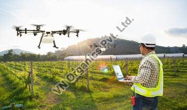
Agriculture Drone Handling Programs
| Camera Technology | Digital Camera |
| Air Vehicle Type | Quadcopter Air |
| Material | Carbon Fiber |
| Features | Vertical takeoff and landing |
| Click to view more | |
Service Details
To produce variable rate prescriptions and calculate the value of our services, use VN Organics Private Limited. By calculating total loss areas following weather catastrophes using aerial maps, you may improve the precision and effectiveness of your insurance claims processing.
Your livelihood comes from your farms. Unfortunately, they are susceptible to damage from pests, harsh weather, and droughts. On the ground, your field of vision is constrained, but using our drone and agriculture drone handling programmes, you can take dozens, hundreds, or even thousands of photographs in a single trip and combine them into a single, richly detailed map.
The construction of intricate picture stitching in your field is possible because of precision imaging. How would this help you? Learn exactly where to reseed, spray, or irrigate, as well as where not to.
Looking for "Agriculture Drone Handling Programs" ?
Explore More Services


